
![]()
Applications can be refer electronically via the Common Electronic Registration, to submit any writing or application, or the electronic site of Ministerio para la Transición Ecológica, for more regular procedures.
May also occur in the registry office of the Hydrographic Confederation of secure Fontes Square, 1, or by any of the forms provided for in Article 16.4 of Law 39/2015, 1 October, Common Administrative procedure of public administrations (post offices, in the diplomatic or consular offices of Spain abroad, and in the offices of assistance in the field of rows).
You must bear in mind that, in accordance with Article 14.2 of law 39/2015 of Common Administrative Procedure (LPAC), will be forced to interact electronically with public administrations for the realization of any handling of an administrative procedure, among others, the following subjects:
- Legal persons.
- Entities without legal personality.
- Those exercising a professional activity for which they need legiació compulsory, for the tape and actions performed with public administrations in exercise of such a professional activity. In any case, within this group are including notaries and registrars of property and business.
- Those who represent a person who is obliged to interact electronically with the administration.
List of definitions
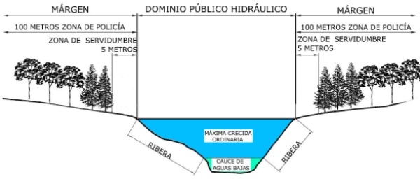
- Hydraulic Public Domain:
- Includes inland waters, both the surface and groundwater renewable, the channels of natural flows continuous or interrupted seagrass lakes, lagoons and reservoirs and aquifers and the water from desalination.
- Channel or Álveo:
- Is the ground covered by the waters in the maximum regular floods. The determination of this area will be based on its characteristics geomorphological, ecological and taking into account the hydrological information, hydraulic, cartographic photographic and they exist, as well as the historical references available.
- Shores:
- Side strips public channels located above the sea level casualties.
- Margins:
- Are the land bordering the channels. The margins are subject, in its entirety longitudinal to an area of servitude five metres wide and a police zone 100 metres wide.
- Area of servitude for public use:
- Between its purpose is the pedestrian public step for the development of monitoring services, conservation and rescue.
- Police zone:
- Is restricted the use of land and activities.
- Plain area:
- Delimited by levels theorists who defeated waters in avenues statistical whose period return is 500 years, according to studies geomorphological, hydrological and hydraulic, as well as of series of historical avenues and documents or historical evidence.
- Maximum ordinary flood:
- Is the average of the maximum annual flow in its natural regime produced for ten consecutive years, which are representative of the hydraulic behaviour of the current.


