
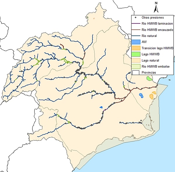
The information collected in the pressure inventory is identified in the form of maps of the demarcation, for the different types of pressures that act on the water bodies.
Detailed information on the pressures identified on the water bodies of the demarcation is available in Annex 7. Pressure Inventory of the Hydrological Plan of the Segura basin.
Pressures on continental surface water bodies
Pollution caused by point pollution sources (discharges and landfills):
The inventoried pressures in the Segura river basin district (DHS) in surface waters, as well as those considered significant inducers of potential negative impact, are the following:
| PRESSURES | TOTAL NUMBER OF PRESSURES INVENTED | NUMBER OF SIGNIFICANT PRESSURES WITH RESPECT TO TOTAL | |
|---|---|---|---|
| POINT SOURCES | Discharges | 141 | 99 |
| Landfills | 45 | 45 | |
| DIFFUSE SOURCES | Diffuse sources (surface water bodies with pressures of the indicated type) | 95 | 95 |
| EXTRACTIONS | Extractions | 261 | 160 |
| MORPHOLOGICAL | Dams | 33 | 33 |
| Azudes | 72 | 57 | |
| Pipelines | 32 | 24 | |
| Margin protection | 54 | 3 | |
| Channel covers | 0 | 0 | |
| River dredging | 2 | 0 | |
| Extraction of aggregates | 28 | 28 | |
| Regrowth of lakes | 0 | 0 | |
| Modification connections | 1 | 1 | |
| REGULATIONS | Incorporation of transfers | 52 | 52 |
| Incorporation of hydroelectric diversions | 61 | 61 | |
| OTHER ANTHROPOGENIC INCIDENCES | Non-native species | 159 | 100 |
| Motorized water sports | 17 | 13 | |
| Contaminated sediment | 0 | 0 | |
| Land drains | 0 | 0 | |
| Others | 104 | 41 | |
| LAND USES | Forest operations in police zone | 48 | 12 |
| Contaminated soils | 0 | 0 | |
Source: Hydrological Plan of the Demarcation of the Segura 2015-2021
Among all of them, the main significant pressures that affect the water bodies of the demarcation are urban discharges and landfills, extractions for agricultural purposes and supplying the population, the pressure linked to the livestock load of certain masses of water, morphological changes (mainly weirs and dams) and the presence of non-native species.
The areas with the highest number of discharges are the middle and lower reaches of the Segura, as well as the Guadalentín river and the Campo de Cartagena. These river sections correspond to the most densely populated areas of the basin, and which also have greater agricultural and industrial use. In recent years, the sanitation network of the small towns in the area has been remarkably improved, and with it, the quality of the effluents and a reduction in their number. In addition, in recent years the quality of urban discharges has improved significantly, which has improved the quality of the water circulating through the water bodies, reducing the appearance of impacts on water, such as the appearance of episodes of eutrophication. .
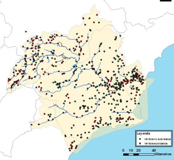
Vertidos urbanos inventariados en la demarcación sobre masas de agua superficiales
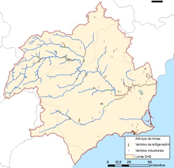
Otros vertidos inventariados en la demarcación
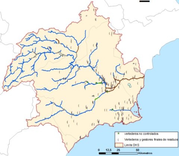
Vertederos, gestores finales e intermedios, así como vertederos no controlados, inventariados en la demarcación
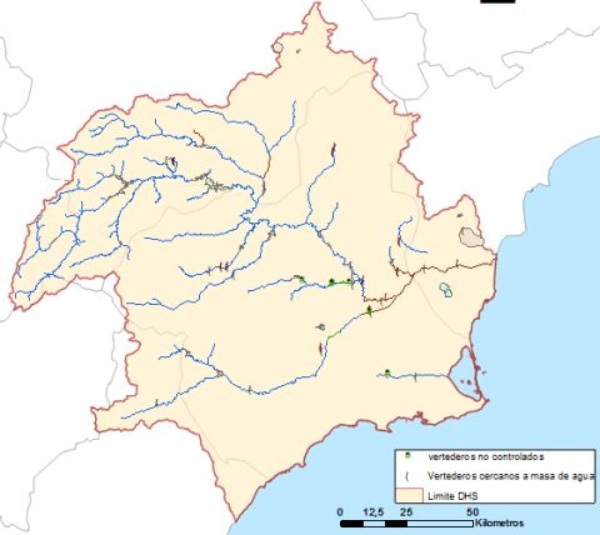
Vertederos, gestores finales e intermedios, así como vertederos no controlados, inventariados en la demarcación próximos a masas de agua superficiales
Pollution caused by sources of diffuse pollution (agriculture, filtrations, etc.):
The pressure for diffuse type pollution has been evaluated based on the analysis of land uses, which integrates the source of the contamination, taking into account the uses developed in the watershed of each body of water (urban facilities and activities, industrial, agricultural and livestock, and other types of activities such as mining areas, contaminated soils or transportation routes, etc.), with special attention to the diffuse contamination derived from agricultural activities and consequent use of fertilizers.
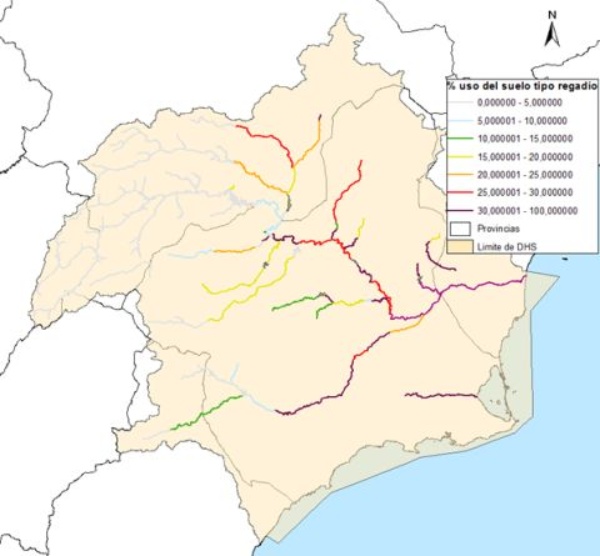
Porcentaje de suelo acumulado (%) dedicado al regadío en las cuencas vertientes de cada masa de agua superficial
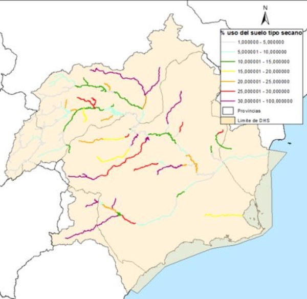
Porcentaje de suelo acumulado (%) dedicado al secano en las cuencas vertientes de cada masa de agua superficial
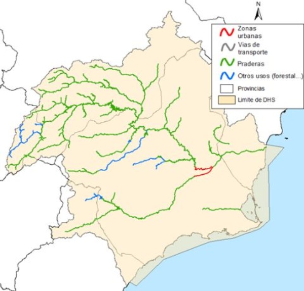
Otros usos del suelo predominantes en cada cuenca vertiente de las masas de agua de tipo superficial
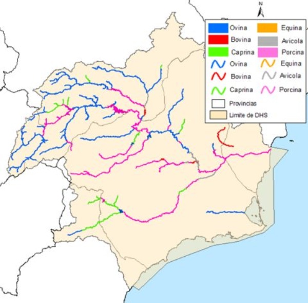
Tipo de ganadería dominante en la cuenca vertiente de cada masa de agua superficial
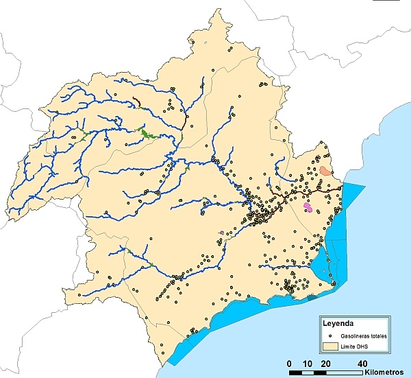
Distribución total de gasolineras en la cuenca
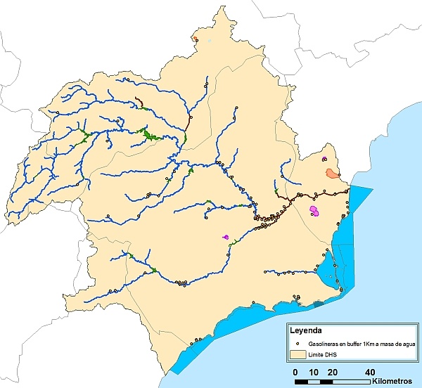
Distribución de gasolineras en la cuenca distantes ≤ 1km a masa de agua superficial
Water extraction in surface waters
The different water extraction points in surface masses of the demarcation have been identified for inclusion in the pressure inventory, using as a starting material the Register of Surface Exploitation of the Commissariat of Waters of the CHS , as well as the catchment inventories carried out by the river basin organization in the last decades.
The following table indicates the number of withdrawals carried out on each surface water body defined in the demarcation, distinguishing between different types of use for them. The number contained in parentheses indicates, of the total number of extractions, how many are significant pressures according to the criteria defined above.
| Mass code | Mass name | Supply to population | Irrigation and agricultural use | Energy production | Other industrial uses | Aquaculture | Recreational | Navigation and transport | Others | Extraction volume (Hm³ / year) |
|---|---|---|---|---|---|---|---|---|---|---|
| ES0701010101 | SAFE RIVER FROM HEADER TO ANCHURICAS RESERVOIR | 0 | 2 (20) | 0 | 0 | 0 | 0 | 0 | 0 | 6.47 |
| ES0701010104 | RIO SEGURA AFTER CONFLUENCE WITH RÍO ZUMETA UNTIL LA FUENSANTA RESERVOIR | 0 | 2 (20) | 0 | 0 | 0 | 0 | 0 | 0 | 1.6 |
| ES0701010109 | RÍO SEGURA FROM CENAJO TO CH DE CAÑAVEROSA | 1 (0) | 11 (0) | 1 (0) | 0 | 0 | 0 | 0 | 0 | 26.15 |
| ES0701010110 | RÍO SEGURA FROM CH CAÑAVEROSA TO QUÍPAR | 0 | 2(0) | 1(1) | 0 | 0 | 0 | 0 | 0 | 6,03 |
| ES0701010111 | RÍO SEGURA FROM CONFLUENCE WITH RÍO QUÍPAR TO AZUD DE OJÓS | 2 (0) | 12 (0) | 0 | 0 | 0 | 0 | 0 | 0 | 23.81 |
| ES0701010113 | RÍO SEGURA FROM THE AZUD DE OJÓS TO DEPURADORA AGUAS BELOW ARCHENA | 0 | 20 (20) | 2 (2) | 0 | 0 | 0 | 0 | 1 (0) | 49.76 |
| ES0701010114 | SAFE RIVER FROM ARCHENA WATER TREATMENT PLANT TO COUNTERFALL | 0 | 14 (0) | 0 | 0 | 0 | 0 | 0 | 2 (0) | 59.4 |
| ES0701010205 | GUADALENTÍN RIVER BEFORE LORCA FROM PUENTES RESERVOIR | 0 | 2 (12) | 0 | 0 | 0 | 0 | 0 | 0 | 5.4 |
| ES0701010301 | RÍO MUNDO FROM CABECERA TO CONFLUENCE WITH RÍO BOGARRA | 0 | 1 (01) | 0 | 0 | 0 | 0 | 0 | 0 | 0.83 |
| ES0701010302 | RÍO MUNDO FROM CONFLUENCE WITH RIO BOGARRA TO TALAVE RESERVOIR | 1 (01) | 2 (0) | 0 | 0 | 0 | 0 | 0 | 0 | 21.49 |
| ES0701010304 | RÍO MUNDO FROM TALAVE RESERVOIR UNTIL CONFLUENCE WITH THE CAMARILLAS RESERVOIR | 0 | 3 (0) | 1 (0) | 0 | 0 | 0 | 0 | 0 | 3.85 |
| ES0701010306 | RÍO MUNDO FROM CAMARILLAS RESERVOIR TO CONFLUENCE WITH SEGURA RIVER | 0 | 1 (0) | 0 | 0 | 0 | 0 | 0 | 0 | 0.15 |
| ES0701010501 | ARROYO BENIZAR | 0 | 4 (0) | 0 | 0 | 0 | 0 | 0 | 0 | 1.38 |
| ES0701010701 | RÍO TUS AGUAS ABOVE THE SPA OF YOUR TUB | 0 | 1 (1) | 0 | 0 | 0 | 0 | 0 | 0 | 1.37 |
| ES0701011001 | ARROYO DE ELCHE | 0 | 3 (0) | 0 | 0 | 0 | 0 | 0 | 0 | 2.65 |
| ES0702051603 | TALAVE RESERVOIR | 0 | 1 (0) | 0 | 0 | 0 | 0 | 0 | 0 | 1.6 |
| ES0701011101 | TAIBILLA RIVER UNTIL CONFLUENCE WITH TAIBILLA RESERVE | 0 | 4 (0) | 0 | 0 | 0 | 0 | 0 | 0 | 1.91 |
| ES0701011103 | TAIBILLA RIVER FROM TAIBILLA RESERVOIR TO ARROYO DE LAS HERRERIAS | 2 (2) | 0 | 0 | 0 | 0 | 0 | 0 | 0 | 36.6 |
| ES0701011201 | BLANCO STREAM UNTIL CONFLUENCE WITH TAIBILLA RESERVOIR | 0 | 4 (0) | 0 | 0 | 0 | 0 | 0 | 0 | 1.91 |
| ES0701011401 | RIO BOGARRA UNTIL CONFLUENCE WITH THE RIO MUNDO | 0 | 1 (1) | 0 | 0 | 0 | 0 | 0 | 0 | 0.13 |
| ES0701011801 | RÍO ALHÁRABE UNTIL CAMPING LA PUERTA | 0 | 13 (13) | 0 | 0 | 0 | 0 | 0 | 0 | 0.89 |
| ES0701011802 | ALHÁRABE AGUAS RIVER BELOW CAMPING LA PUERTA | 0 | 38 (38) | 0 | 0 | 0 | 0 | 0 | 0 | 2.41 |
| ES0701011901 | RÍO ARGOS BEFORE THE RESERVOIR | 0 | 252 (252) | 0 | 0 | 0 | 0 | 0 | 0 | 20.2 |
| ES0701011903 | RÍO ARGOS AFTER THE RESERVOIR | 0 | 28 (28) | 0 | 0 | 0 | 0 | 0 | 0 | 2.97 |
| ES0701012001 | RAMBLA TARRAGOYA AND BARRANCO JUNQUERA | 0 | 9 (9) | 0 | 0 | 0 | 0 | 0 | 0 | 2.17 |
| ES0701012002 | QUÍPAR RIVER BEFORE THE RESERVOIR | 0 | 215 (215) | 0 | 0 | 0 | 0 | 0 | 0 | 8.97 |
| ES0701012301 | RÍO MULA TO THE CIERVA RESERVOIR | 0 | 43 (43) | 0 | 0 | 0 | 0 | 0 | 0 | 2.66 |
| ES0701012303 | RÍO MULA FROM THE RESERVOIR OF LA CIERVA TO RÍO PLIEGO | 0 | 3 (3) | 0 | 0 | 0 | 0 | 0 | 0 | 0.22 |
| ES0701012304 | RÍO MULA FROM THE PLIEGO RIVER TO THE RODEOS RESERVOIR | 0 | 3 (3) | 0 | 0 | 0 | 0 | 0 | 0 | 2.51 |
| ES0701010401 | RÍO ZUMETA FROM ITS HEADBOARD UNTIL CONFLUENCE WITH RÍO SEGURA | 0 | 6 (60) | 0 | 0 | 0 | 0 | 0 | 0 | 1.43 |
| ES0701012401 | RÍO PLIEGO | 0 | 2 (2) | 0 | 0 | 0 | 0 | 0 | 0 | 1.57 |
| ES0701012601 | RÍO CHÍCAMO AGUAS ABOVE EL PARTIDOR | 0 | 1 (1) | 0 | 0 | 0 | 0 | 0 | 0 | 0.46 |
| ES0701012901 | RAMBLA DE CHIRIVEL | 0 | 1 (0) | 0 | 0 | 0 | 0 | 0 | 0 | 0.05 |
| ES0701012902 | RÍO CORNEROS | 0 | 3 (0) | 0 | 0 | 0 | 0 | 0 | 0 | 3.99 |
| ES0702050112 | EMBALSE DEL AZUD DE OJÓS | 3 (0) | 2 (0) | 0 | 0 | 0 | 0 | 0 | 0 | 135.24 |
| ES0702050108 | CENAJO RESERVOIR | 0 | 1 (0) | 0 | 0 | 0 | 0 | 0 | 0 | 0.49 |
| ES0702082503 | SALT RAMBLA | 0 | 4 (0) | 0 | 0 | 0 | 0 | 0 | 0 | 22.12 |
| ES0702080115 | RIVER SEGURA CHANNELING, BETWEEN PILOT AND REGUERÓN | 0 | 7 (0) | 0 | 0 | 0 | 0 | 0 | 0 | 9.38 |
| ES0702080116 | RIVER SEGURA ROUTING, FROM REGUERÓN TO UNLOADING | 0 | 41 (41) | 0 | 0 | 0 | 0 | 0 | 0 | 292.07 |
| ES0702081703 | TOBARRA STREAM FROM CONFLUENCE WITH RAMBLA DE ORTIGOSA TO RÍO MUNDO | 0 | 2 | 0 | 0 | 0 | 0 | 0 | 0 | 1.8 |
| TOTAL | 9(3) | 244(154) | 5(3) | 0(0) | 0(0) | 0(0) | 0(0) | 3(0) | ||
| 261(160) | 765,63 | |||||||||
Source: Segura Demarcation Hydrological Plan 2015-2021
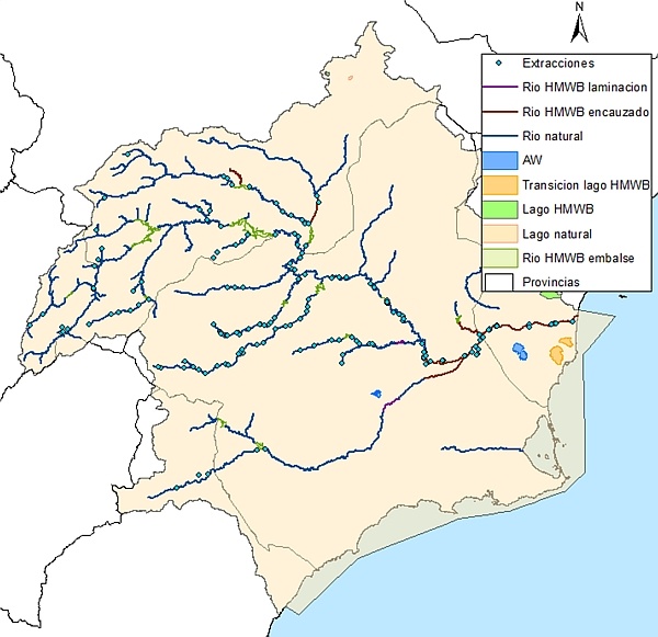
Distribución de los puntos de extracción de recursos sobre las masas de agua superficiales de la demarcación
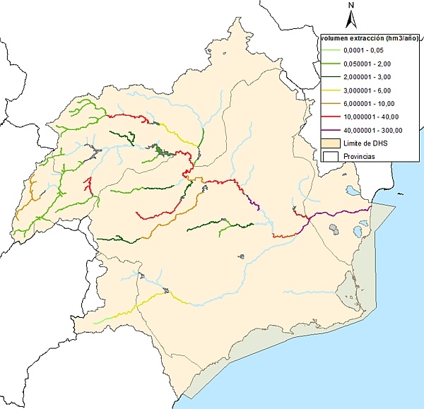
Volumen de extracción practicado en cada masa de agua superficial de la demarcación
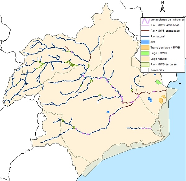
Morphological alterations and flow regulation:
As stated in the Hydrological Plan of the demarcation, in the pressure inventory compiled in the DATAGUA Database, the incidence of the regulation of water flow, including transfers and diversions of water, has been estimated and determined in global characteristics of flow and water balance. Likewise, significant morphological changes in water bodies have been identified, including transverse and longitudinal changes.
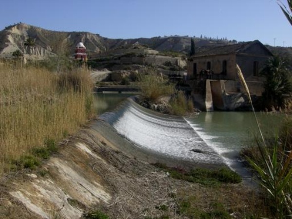
Villanueva del Río Segura
The following table summarizes the morphological alterations and flow regulation in river water bodies of the Segura river basin district, shown in the General Study of the District:
| Pressure | Inventoried | Significant Number |
|---|---|---|
| Dams | 33 | 33 |
| No. Transfer additions | 52 | 52 |
| No. Incorporations of hydroelectric diversions | 61 | 61 |
| Azudes | 72 | 58 |
| Pipelines | 32 | 24 |
| Margin protections | 53 | 3 |
| River dredging | 2 | 0 |
| Extraction of aggregates | 28 | 28 |
Source: Segura Demarcation Hydrological Plan 2015-2021
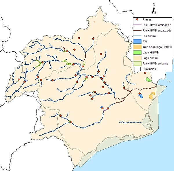
Situación de las presas inventariadas en la demarcación
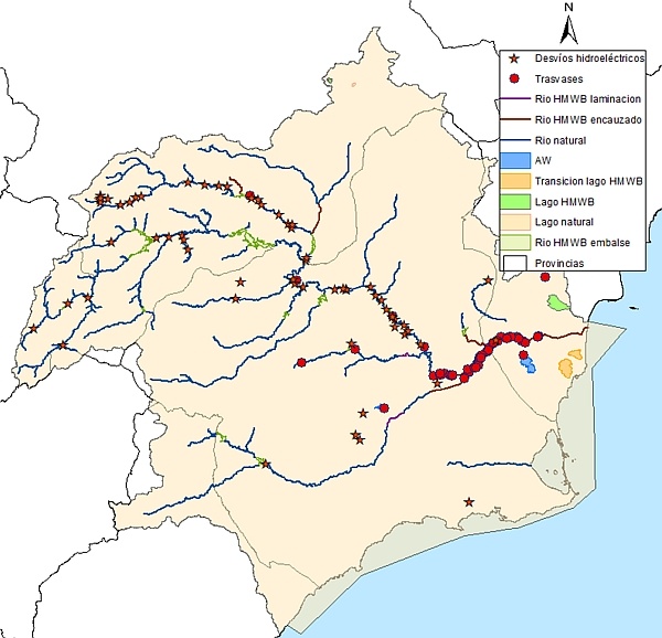
Situación presiones por trasvase (incorporaciones de recursos a cauce procedentes de trasvases intercuencas y pozos de sequía) y desvíos hidroeléctricos inventariados en la demarcación
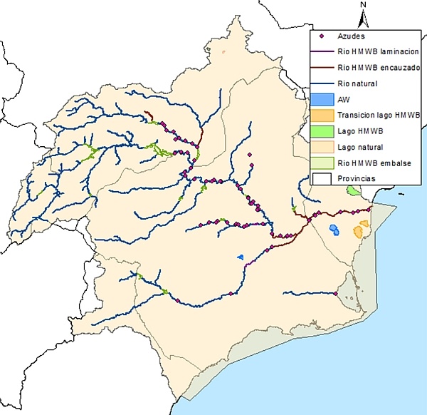
Situación de los azudes inventariados en la demarcación
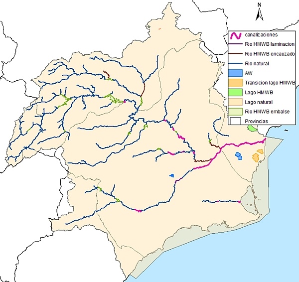
Situación de las canalizaciones inventariadas en la demarcación

Situación de las protecciones de márgenes inventariadas en la demarcación
Situación de los dragados inventariados en la demarcación
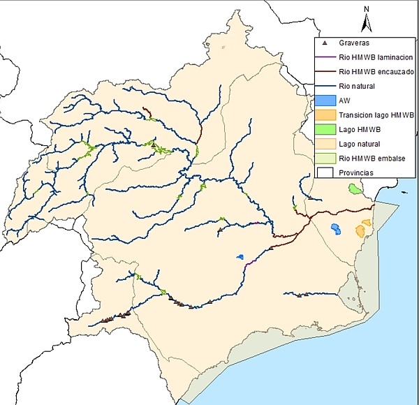
Situación de las extracciones de áridos (graveras) inventariadas en la demarcación
48 forest exploitations have been inventoried (almost exclusively poplar) that present more than 5 hectares in a police area in the public hydraulic domain. Of these, 12 have been considered as significant pressures for presenting equal to or more than 500 m along the channel.
Likewise, the modification of the natural connection with other water bodies of the El Hondo lagoon, which receives resources from the Segura and azarbes river, has been identified as significant pressure.
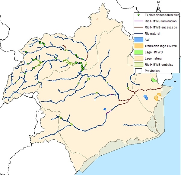
Situación de las explotaciones forestales inventariadas en la demarcación

Situación de las modificaciones de las conexiones naturales entre masas inventariadas en la demarcación
Other anthropogenic incidents inventoried in the demarcation:
According to the Basin Hydrological Plan, this denomination includes other pressures resulting from human activity that are difficult to classify and that cannot be included in any of the previously defined groups, such as the introduction of non-native species, contaminated sediments, drainage land, water sports, fishing grounds, etc.
| Pressure | No. Pressures inventoried | No. Significant pressures |
|---|---|---|
| Non-native species | 159 | 100 |
| Contaminated sediment | 0 | 0 |
| Potentially contaminated soils | 0 | 0 |
| Other pressures | 104 | 41 |
Source: Segura Demarcation Hydrological Plan 2015-2021
Situación de otras presiones inventariadas en la demarcación
Pressures on groundwater bodies
Qualitative pressures
The underground water bodies with the highest identified qualitative pressures are those linked to highly anthropized areas (large percentages of land destined for agricultural activities, mainly rainfed, except in those areas where the presence of resources and the orography of the demarcation favors the start of irrigation production). These masses have the greatest number of significant sources of pollution (mainly agricultural). This circumstance is accentuated in the middle and lower areas of the demarcation, as well as in coastal areas, places with significant anthropic activity.
In accordance with the provisions of the IPH on diffuse type pollution, in the writing of the PHDS 2015/21, the inventory of land uses by underground mass has been updated, with the use of the SIGPAC for the year 2010 < / p>
In the Annex 07. "Pressures Inventory" (34.8 MB) the results of the analysis of the land uses on each body of water and the significant point sources of contamination are shown.
| MASSES | SIGNIFICANT SOURCES OF CONTAMINATION | ||||||||
|---|---|---|---|---|---|---|---|---|---|
| Landfills and intermediate managers of non-hazardous waste | Uncontrolled landfills | Landfills and intermediate managers of hazardous waste | WWTP | Gas Stations | Mining rafts | Mining dumps | Authorized discharges | Unauthorized dumping | |
| Total | 64 | 5 | 121 | 390 | 80 | 44 | 242 | 93 | |
Source: General Study of the Segura River Basin District 2015-2021
Quantitative pressures
Below is a summary table where significant quantitative pressures are indicated, as well as their origins.
| No. of masses affected | % affected masses | ||
|---|---|---|---|
| GROUND WATER EXTRACTION | Agricultural uses | 40 | 63% |
| Agricultural uses | 21 | 33% | |
| Industrial uses | 20 | 32% | |
| Quarries and open pit mines | |||
| Other significant extractions | |||
| ARTIFICIAL RECHARGE | Discharges to subt waters. for artificial recharge of aquifers | ||
| Returns of groundwater to the mass from which it was extracted (aggregate washing) | |||
| Recharge with mine bilge water | |||
| Other significant recharges | |||
| OTHER PRESSURES | Saline intrusion | 10 | 16% |
| Other type of intrusions |
Source: General Study of the Segura River Basin District 2015-2021
Regarding pressures on underground water bodies, 32 of the 63 identified water bodies (51% of the total existing ones) show a significant pressure associated with withdrawals due to having an exploitation index greater than 0 , 8.
On the other hand, the piezometric and hydronomic analysis of springs carried out on the water bodies of the demarcation, shows how 31 underground bodies have a proven impact due to piezometric drops and 8 underground masses have a proven impact due to a decrease in flows drained by springs subject to foronomic control by the Segura Hydrographic Confederation.
| Proven impact | ||
|---|---|---|
| No. masses | Total % | |
| Piezometric descent | 31 | 49% |
| Lowering spring flows | 8 | 13% |
| Identification of the global quantitative impact | 32 | 51% |
Source: General Study of the Segura River Basin District 2015-2021
Presiones sobre las masas de agua costeras y de transición
Coastal and transitional bodies of water in the province of Alicante
Taking into account the differential characteristics of coastal waters, and especially those of the Mediterranean, pressures have been classified
The ES070103001 Guardamar-Cabo Cervera mass has been considered with significant pressure due to the phosphorus contributions derived from the Segura, together with those generated by the existing marine farm facilities in the area.
| Body of water code | Name | Point source | Fuzzy source | Morphological alterations | Other | Global |
|---|---|---|---|---|---|---|
| ES070103001 | Guardamar-Cabo Cervera | Significant | Not significant | Not significant | No data | Significant |
| ES070103002 | Cabo Cervera-Límite CV | Not significant | Not significant | Not significant | No data | Not significant |
Source: Hydrological Plan for the Demarcation of the Segura 2015-2021
Lagunas de la Mata - Torrevieja present significant morphological alterations, which is why they have been designated as HMWB .
These lagoons receive through a series of ravines irrigation return waters (especially on the eastern margin of the Torrevieja lagoon) where the presence of pesticides has also been detected, so this pressure has been considered as significant . The nitrogen contribution from the El Pinoso deposit must also be considered.
| Body of water code | Name | Point source | Fuzzy source | Morphological alterations | Others | Global |
|---|---|---|---|---|---|---|
| ES070103001 | La Mata Lagoons - Torrevieja | Significant | Not significant | Significant | No data | Significant |
Coastal water bodies of the Region of Murcia
| MASS WATER CODE | MASS | MASS OF WATER CATEGORY | PRESSURES | |||
|---|---|---|---|---|---|---|
| Punctual | Fuzzy | Alt. morphological | Extractions | |||
| ES0701030003 | Mojón-Cabo de Palos | Natural coastal | - Urban discharges: 1 (EDAR San Pedro) -Disposal of desalination plants: 1 -Farms: 1 (not significant) -Disposal of storm or rain: outfalls - emergency spillways: 9 |
- Puerto San Pedro -Navigation -Navy exercise areas -Puerto Aquaculture San Pedro del Pinatar |
- Puerto Deportivo de San Pedro -Sports Dock “Marina de Las Salinas” -Puerto Mayor -Dukes exempt: 2 -Directions of channeling : 1 -With groynes: 3 -Regenerated beaches: 3 -Tidal surface occupations: 3 |
No pressure |
| ES0701030004 | Cabo de Palos-Punta Espada | Natural coastal | - Urban discharges: 1 (WWTP Mar Menor Sur) -Destrocation discharges: 1 |
- Port of Cabo Palos -Navigation |
- Puerto Deportivo de Cabo de Palos | No pressure |
| ES0701030009 | Punta Espada-Cabo Negrete | Natural coastal | No pressure | No pressure | No pressure | No pressure |
| ES0702150006 | Cabo Negrete-La Manceba | Costera HMWB | No pressure | - Polluted areas on the coast: Bahía de Portmán -Bayía de Portmán |
- Aquaculture zones: 1 -Regenerated beach: 1 -Dársena El Gorguel |
1 |
| ES0701030013 | La Manceba-Punta Aguilones | Natural coastal | - Industrial refrigeration and industrial discharges: 2 -Other Industrial discharges: 2 |
- Influence of the contaminated area of Portmán -Maritime traffic |
- Morphological alteration in Dársena de -Escombreras | Water extraction: for cooling and desalination |
| ES0702120005 | Punta Aguilones-La Podadera | Costera HMWB | - Industrial discharges: 4 -Biodegradable industrial discharges: 2 (not significant) -Industrial cooling discharges: 2 -Heat discharges: 2 -Desalt machines: 1 |
- Port of Cartagena -Dársena de Escombreras -Intense maritime traffic |
- Puerto Deportivo de Cartagena -Yacht dock in Cartagena -Dársena de Escombreras, -New Dock -Espigones: 2 -Regenerated Beaches: 1 |
Water withdrawals: for cooling: 2 Water withdrawals for vaporization: 1 Water withdrawals: for desalination: 1 |
| ES0701030006 | La Podadera-Cabo Tiñoso | Natural coastal | Urban discharges: 1 | - Service Area of the Port of Cartagena -Navy exercise area -Maritime traffic |
Intertidal land occupations: 2 | No pressure |
| ES0701030012 | Cabo Tiñoso - Punta de la Azohía | Natural coastal | No pressure | No pressure | No pressure | No pressure |
| ES0701030011 | Punta de la Azohía-Punta de Calnegre | Natural coastal | - Discharges of desalination plants: 3 (1 not significant) -Urban discharges: 1 -Pisciferia: 1 (not significant) |
- Dragging due to rain from the Sierra Minera Mazarrón (heavy metals) Contaminated area on the S shoreline> 5000 m² -Puerto Deportivo de Mazarrón -Dársena Deportiva de Mazarrón -Supports of waste water (next to the hermitage of the island) -Supports from agriculture -Aquaculture area: 1 |
Puerto Deportivo de Mazarrón Dársena Deportiva de Mazarrón Breakwaters: 3 Occupations of the intertidal lands: 9 Regenerated beaches: 2 Exempt levees: 3 |
Water extractions: for desalination plants: 1 |
| ES0701030007 | Punta de Calnegre- Punta Parda | Natural coastal | - Discharges of desalination plants: 3 -Farms: 1 (not significant) -Urban discharges: 1 (EDAR Ayto. Águilas) |
- Fishing Port-Sports of Águilas -Puerto Deportivo de Águilas -Puerto Deportivo Playa de Poniente "Casica Verde" (Juan Montiel) - Aquaculture areas: 1 -Adult contributions from agriculture |
- Alteration of the bottom of the Hornillo Bay for navigation (former mining activity) -Puerto Pesquero-Deportivo de Águilas -Puerto Deportivo de Águilas - Poniente Beach Sports Port “Casica Verde” (Juan Montiel) -Esigigones: 5 -Regenerated beaches: 4 -Except levees: 1 |
Water extractions: for desalination plants: 2 |
| ES0701030008 | Mojon-Cabo Negrete | Natural coastal | - Urban discharges: 2 (EDAR San Pedro and EDAR Mar Menor Sur) -Disposal of desalination plants: 2 |
- Aquaculture zones: 4 -Navigation |
Sands extraction zone | No pressure |
| ES0702150007 | Cabo Negrete-La Manceba | Costera HMWB | No pressure | Contaminated area on the coast: Portmán Bay Aquaculture area: 1 Heavy maritime traffic |
No pressure | No pressure |
| ES0701030010 | La Manceba-Punta Parda | Natural coastal | No pressure | - Service Area of the Port of Cartagena -Navy exercise area -Maritime traffic -Aquaculture zones: 2 | No pressure | No pressure |
| ES0701030005 | The Mar Menor | Natural coastal | - Discharges of desalination plants: 2 -Urban discharges: 2 -Various illegal discharges |
- Pollution from the influence of agricultural activities in the Campo de Cartagena -Ports: 10 (Lo Pagán, Embarcadero-Fondeadero La Ribera, Los Alcázares, Los Urrutias, Los Nietos , Islas Menores, Mar de Cristal, La Isleta, Dos Mares, Tomás Maestre) -Recreational navigation -Supports of wastewater -Trains due to rain from the Sierra MineraLa Unión through the Rambla del Beal, Barranco Ponce and Rambla de la Carrasquilla (heavy metals) Polluted area on the coast S> 5000 m² |
- Modification of the connection with other water bodies: 1 (Canal del Estacio) -Ports: 10 ((Lo Pagán, Embarcadero-Fondeadero La Ribera, Los Alcázares , Los Urrutias, Los Nietos, Islas Menores, Mar de Cristal, La Isleta, Dos Mares, Tomás Maestre) -Espeigones: 41 -Artificial beaches: 8 -Ducation channels: 7 -Trench land occupations: 12 -Length defense structures: 4 -Except levees: 4 -Margin protections: 1 |
No pressure |
Fuente: CARM . Ministry of Industry and Environment. General Directorate for Environmental Quality. Environmental Monitoring and Inspection Service, June 2015
Coastal water bodies of the Province of Almería
The identification and characterization of pressures in the area of coastal and transitional waters of the province of Almería in the Segura demarcation has been based on the information on authorized discharges and the Coastal Waters Plan of the Segura demarcation (Directorate General of Prevention and Environmental Quality of the Ministry of Environment of the Junta de Andalucía).
An urban discharge from the WWTP in San Juan de los Terreros has been inventoried, for the portion of the demarcation belonging to the aforementioned autonomous community, that purifies the waters of this nucleus with a secondary treatment and whose discharge is made through an underwater outfall. Likewise, a spill of brine from the desalination plant El Cocon, in the municipality of Pulpí, has been inventoried.
Likewise, and with regard to sources of diffuse contamination, the Andalusian part of the DHS forms a less anthropic environment, consisting mainly of halophile scrub and spaces with little vegetation. However, the presence of agriculture is observed, especially irrigated crops.
The origin of Nitrogen in this body of water, it is estimated that it comes from irrigation with a contribution of approximately 16 Tn / year of Total Nitrogen.
In the Andalusian part of the demarcation there are no port facilities and the development of activities such as navigation meets with a series of restrictions, due to the existence of a marine protected area of special relevance (Levante Almeriense seabed), to the existence of two zones of extraction of aggregates and its consideration as a Zone of Military Interest. Due to all these restrictions, it is not considered probable the existence of accidental spills whose effects could last for a significant period of time.
Similarly, no potentially soil-polluting activities have been identified, nor have port facilities (and therefore there are no dredges for port dredging material), nor are there any marine aquaculture facilities.
The Coastal Waters Plan of the Segura demarcation identifies 2 groynes as morphological alterations.


