
Flood hazard and risk maps are a fundamental tool for flood risk management in the Segura River Basin District. Their development complies with Royal Decree 903/2010, which mandates the creation of these maps for each Area of Significant Potential Risk (ARPSI) identified in the Preliminary Flood Risk Assessment (EPRI) for the district.
These maps are continuously reviewed and updated to incorporate changes in the territory and the best available hydrological and hydraulic information.
Three probability scenarios are analyzed according to the return period: high (10 years),medium (100 years) and low (500 years).
- Hazard Maps: They delimit the floodable area and the associated variables (depths, speed, preferential flow zone).
- Risk Maps: They integrate the hazard with the vulnerability of the territory (human health, environment and economic activity).
Regarding the flood hazard and risk maps of fluvial origin, in accordance with Article 10.1 of Royal Decree 903/2010 on flood risk assessment and management, the Segura River Basin Authority is the competent body for preparing this information.
The flood hazard and risk maps for riverine floods have been prepared in accordance with the content of the "Methodological Guide for the development of the National System of Flood Zone Mapping (SNCZI), Preliminary Risk Assessment", from the Ministry of Agriculture, Food and Environment" (currently the Ministry for Ecological Transition and the Demographic Challenge).
The following fact sheets provide detailed information on flood hazard and risk mapping, as well as the boundaries of the Public Water Domain and the preferential flow zone:
Regarding the maps of marine flood hazards and risk in coastal and transitional waters, Article 10.1 of Royal Decree 903/2010, on flood risk assessment and management, establishes that the Directorate General for the Sustainability of the Coast and the Sea of the Ministry for Ecological Transition and the Demographic Challenge is the competent body for preparing this information.
These maps have been developed within the framework of the project “Development of the methodology and databases for projecting the impacts of climate change along the Spanish coast”, in which the necessary methodology for their generation was defined.
The impact of climate change on coastal flooding in Spain was expressly considered in their development, in accordance with the provisions of the Floods Directive.
Given that this impact is adequately quantified with respect to the historical reference period, and as long as the databases used to create these maps during the first implementation cycle of the Directive remain unchanged, the Directorate General for the Sustainability of the Coast and the Sea concludes that it is not necessary to produce new coastal flood hazard maps in the current cycle.
Consequently, the maps already published in the National Flood Zone Mapping System remain valid.
More detailed information on the hazard and risk maps for flooding caused by the sea in coastal and transitional waters can be found in the following documents:
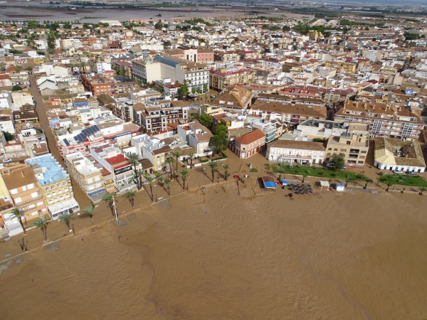
Santa María flash flood, September 13, 2019. (Los Alcázares, Murcia). Source: Civil Protection of the Region of Murcia
Note on technical limitations: Flood maps are developed using theoretical flood studies, which implies certain limitations compared to what occurs in an actual flood. Although they employ high-precision models, real-world events can vary due to phenomena such as erosion, landslides, sedimentation or sediment transport, potential obstructions, or changes in flow caused by elements such as trees, vehicles, or infrastructure failures, or direct rainfall on already flooded areas. Despite this, they are the most effective tool for sustainable planning and damage mitigation.
In accordance with Article 10 of Royal Decree 903/2010, the currently approved and published hazard and risk maps have undergone a 3-month public consultation process and have been reviewed by the Committee of Competent Authorities of the Segura River Basin District.
For an interactive view of all official maps, please visit:
THIRD PLANNING CYCLE (2028-2033)
- CAC report date: March 16, 2026.
SECOND PLANNING CYCLE (2022-2027)
- CAC report date:February 12, 2020.
FIRST PLANNING CYCLE (2016-2021)
- CAC report date:December 22, 2014.


