
At this time the date of the following calls has been closed:
| Date | Event | Place of celebration (11.00 AM) | State |
|---|---|---|---|
| 24/10/2013 | Supply and Sanitation Table | CHS Boardroom. Plaza de Fontes 1. Murcia | Celebrated |
| 29/10/2013 | Coastal Waters Table | CHS Boardroom. Plaza de Fontes 1. Murcia | Celebrated |
| 20/11/2013 | Agrarian and Socioeconomic Table | Chamber of Commerce. Plenary Hall 4th floor. San Bartolomé Square. Murcia | Celebrated |
| 26/11/2013 | Environmental Table and I+D+i | CHS Boardroom. Plaza de Fontes 1. Murcia | Celebrated |
| Date | Event | Place of celebration (11.00 AM) | State |
|---|---|---|---|
| 24/09/2013 | Territorial table of the Segura and Mundo y Sureste headwaters of Albacete | Assembly Hall of the House of Culture. Nuns Square. Hellin | Celebrated |
| 26/09/2013 | Altiplano territorial table | Roque Baños Sociocultural Center Los Gavilanes Room. Plaza de la Alcolera, 3 Jumilla |
Celebrated |
| 01/10/2013 | Territorial table of the Northwest of Murcia and Mula | House of Culture Assembly Hall. Plaza del Templete, 1 Caravaca de la Cruz |
Celebrated |
| 03/10/2013 | Territorial table of Las Vegas del Segura and South of Alicante | Chamber of Commerce Plenary Hall 4th floor. Plaza de San Bartolomé. Murcia |
Celebrated |
| 08/10/2013 | Southwest Territorial Table - Guadalentín Valley | Chamber of Commerce Assembly Hall. Low level. Caño Square, 3 Lorca |
Celebrated |
| 10/10/2013 | Territorial table of Campo de Cartagena | Polytechnic University of Cartagena Hall of Degrees of the ETS of Telecommunications Engineers. Barracks of Antigones. Muralla del Mar. Cartagena |
Celebrated |
| Date | Event | State |
|---|---|---|
| 30/10/2007 | Presentation session of the planning process | Celebrated |
| 20/11/2007 | Announcement of the sectorial environmental table | Celebrated |
| 22/11/2007 | Convocation of the socioeconomic sector table | Celebrated |
| 29/11/2007 | Announcement of the agrarian sectorial table | Celebrated |
| 10/12/2007 | Announcement of the sectoral table of coastal waters of Valencia | Celebrated |
| 10/12/2007 | Announcement of the sectorial table of coastal waters of Andalusia | Celebrated |
| 12/12/2007 | Announcement of the sectoral table of coastal waters of Murcia | Celebrated |
| 13/12/2007 | Announcement of the sectoral table of urban, industrial and purification supply | Celebrated |
As tools for Active Public Participation between the Cuenca Organism and the interested parties, public dissemination sessions, information sessions, and sectorial and territorial tables will be organized so that the entire Demarcation is covered.
The purpose of the sectoral and territorial tables is:
- Promote dialogue and mediation as strategies for the elaboration of the Hydrological Plan of the Segura Demarcation.
- Design and implement a process of citizen participation that collects, analyzes and systematizes the perceptions, opinions and suggestions, as well as the main criticisms and potentially conflictive aspects expressed by the various actors around the process.
- Recognize the legitimacy of all positions.
- To promote a common scenario among all the protagonists related to the management of water in the Segura, highlighting the interests that unite them and creating adequate channels to face the points that separate them.
- Prepare a database with information on stakeholders relevant to the process.
- Present the conclusions obtained during the public participation process in the most relevant forums related to water management in Segura.
- Prepare, based on the perceptions and opinions of the various interested parties, recommendations of aspects to improve to be incorporated in the design of the Hydrological Plan of the Segura Demarcation.
- Involve the set of regional and state institutions in the preparation of the future Hydrological Plan.
SECTORAL TABLES
The sectoral tables will establish a framework of active public participation between the social and economic agents, grouped by the sectors affected by the new Cuenca Hydrological Plan, and the Hydrological Planning Office of the Segura Hydrographic Confederation. 7 sector tables have been created, which are the following:
- Socio-economic table.
- Agrarian table.
- Environmental table.
- Supply table.
- Coastal waters table (Murcia Region).
- Table of coastal waters (Valencian Community).
- Coastal waters table (Andalusia).
In these tables, apart from promoting public consultation of the initial documents of the public participation process, any suggestion or contribution that may be made by the members of the tables to the planning process in general, and in particular, of the documents that are in the process of public consultation, within the new planning process.
TERRITORIAL TABLES
The territorial tables will respond to a geographical distribution consisting of regional groupings, in such a way that they bring together homogeneous stakeholders in terms of sector of interest and with implementation in the corresponding regions.
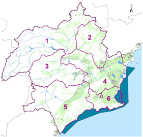
Regional Groups
- Segura and Mundo and Sureste headwaters of Albacete
- Altiplano
- Northwest of Murcia and Mula
- Vegas del Segura and South of Alicante
- Southwest - Guadalentín Valley
- Campo de Cartagena


